 HopNews
Readers may remember that at the 2023 Annual Town Meeting, Hopkinton voted to approve the purchase of the Jenner property, a 42-acre lot near Saddle Hill Road. The Open Space Preservation Commission (OSPC) stated their plan to buy the undeveloped parcel from the Jenner family for an amount not to exceed $150,000, and to preserve the open space and expand the existing network of trails.
Prior to Town Meeting, the Jenners agreed to sell the parcel for $100,000, and in preparation for the sale, J.D. Marquedant & Associates was given the task to survey the land. As part of their process, they sought to pull the deed history for the parcel, and this is where our mystery begins.
On the Town of Hopkinton parcel map, the Jenner property is presented as a single, contiguous 42-acre parcel.
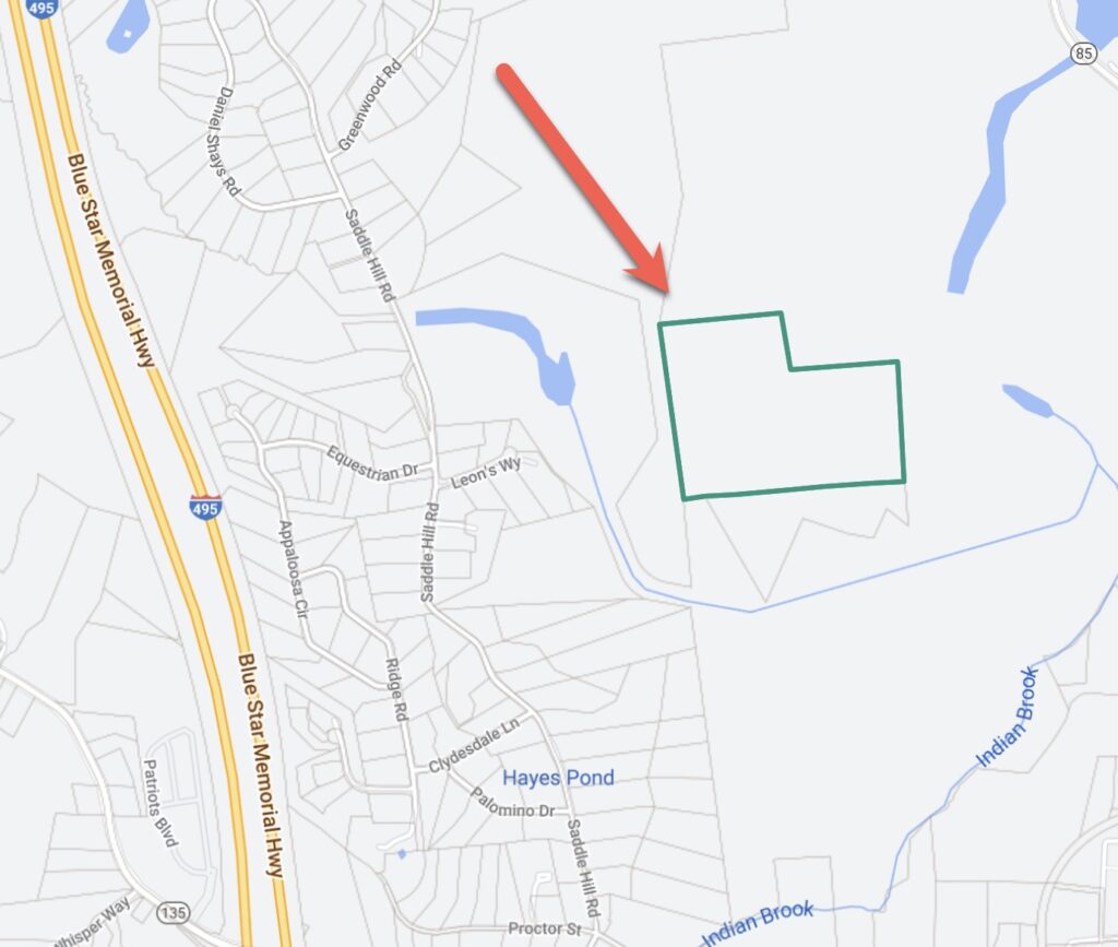
But on the Massachusetts Interactive Property Map, there is an unlabeled thin green line that bisects the parcel, connecting Duck Pond to the larger section of Hopkinton State Park.
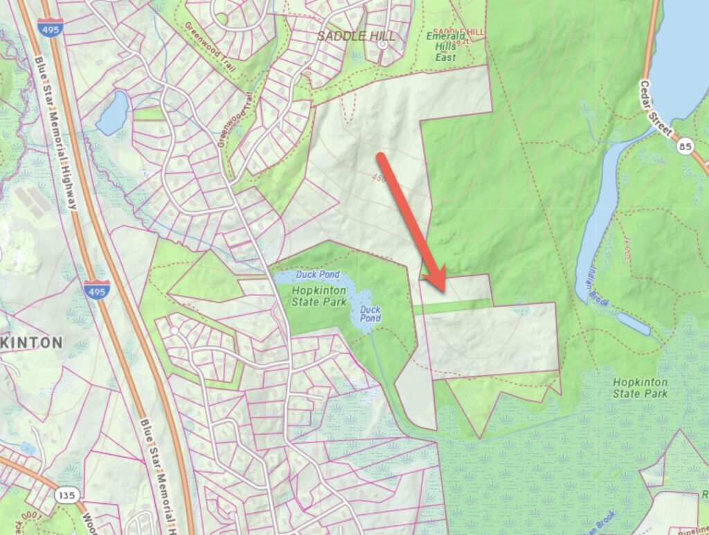
Marquedant reported their findings to the town, and OSPC Chair Ed Harrow began researching the deed history this summer. He too ran into a dead end. His research took him to the Middlesex Registry of Deeds, the Suffolk Superior Courthouse, and finally the Hopkinton State Park Ranger Station to see if they could shed any light on the matter. Indeed, the ranger station has a drawer full of printed maps, two with the ‘Jenner’ property included. The most recent was revised January 1, 1982. The 1982 map mirrors the Town of Hopkinton parcel viewer showing a single contiguous parcel, but another map from 1925 shows the bisected parcel that matches the state’s website.
The 1925 map only added to the complexity. Instead of three parcels, it showed four, which we have annotated in the following image for easier reading. The above and below parcels were owned by Dr. Edgar A. Briggs, with a thin strip (7.05 acres) and an adjacent parcel owned by Charles Claflin, Jr., the grandson of William B. Claflin (Claflin #1 and #2).
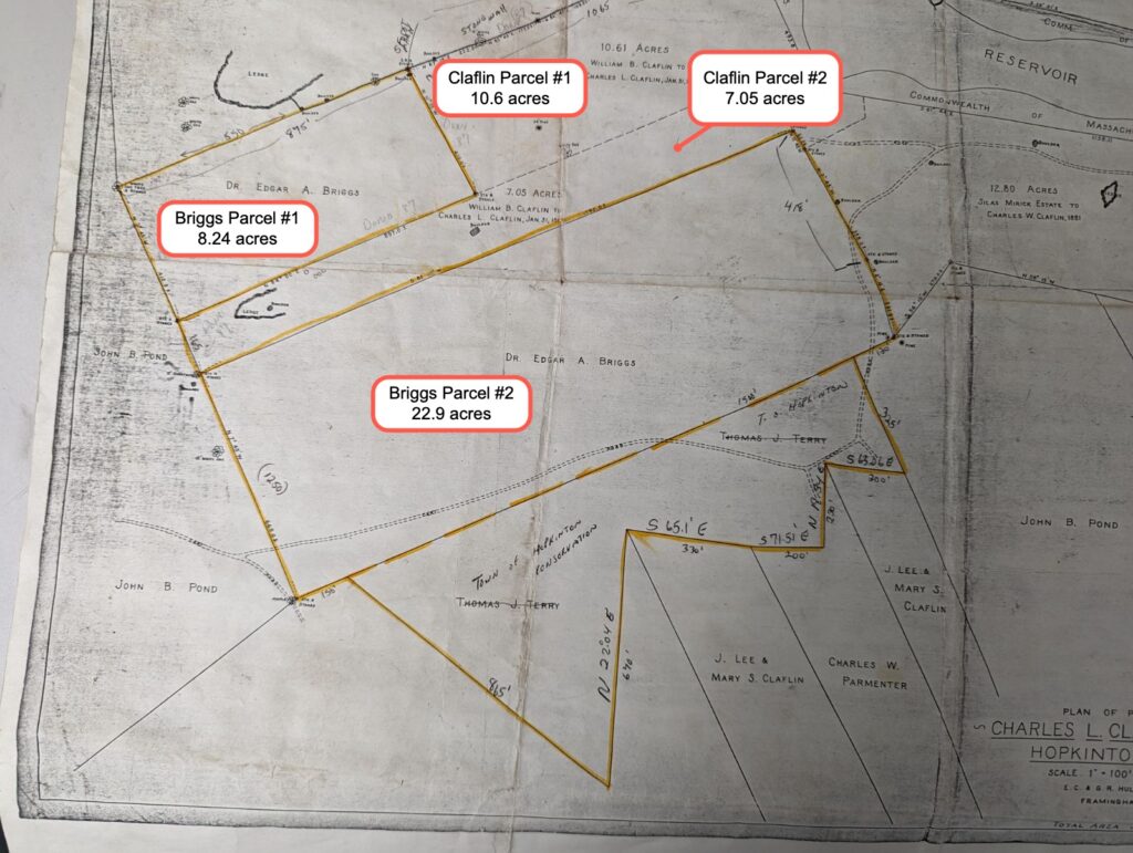
The Claflin family has a long and distinguished history in Hopkinton. William Claflin was a Massachusetts representative, and served from 1849 to 1853. In 1868 he became Massachusetts governor, and during his tenure promoted voting rights for women, prison reform, public health and other social causes. Along with his father Lee, he chartered Boston University as a Methodist college, and later Claflin University in South Carolina, one of the first Historically Black Colleges in the US.
Dr. Briggs arrived in Hopkinton in 1882 and set up his dental practice on Main Street. But in 1900 his building burned in a forest fire that swept into the downtown area. Briggs served on the Board of Selectman from 1924-1925 and died in 1927 at the age of 71.
OSPC Chair Harrow discovered that In 1937, the parcels owned by Briggs were reclaimed by the town for non-payment of taxes. Dr. Briggs and his wife Gertrude (who died in 1934) had no children, so it is logical to conclude that this was why the taxes went unpaid. In 1948, the parcels were purchased by a Mr. Rice. The 10.6 acre parcel (Claflin #1 in the annotated map) now appears to be owned by the Department of Conservation and Recreation, for which Harrow has found no record of transfer.
The Jenner family descends from Mr. Rice. The Rice family were among the earliest settlers in Woodville, and in the 1800’s built several brick homes to accommodate the village’s growing number of residents. Rice Street off of Route 135 is named after them.
In his research to date, Harrow can find no recorded deed that describes the transfer of Claflin’s 7-acre parcel, the one that bisects the Jenner property. To add to the confusion, according to the 1925 map, the dimensions of the combined parcels do not sum to the 42 acres that the Jenner family owns. If the seven acre Claflin section is included, the total parcel size is 38 acres. Without the Claflin section the two parcels are just 31 acres.
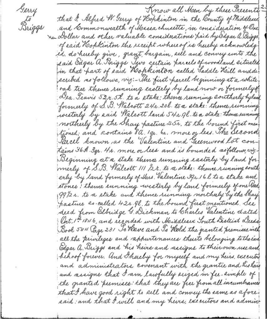
In defense of our forefathers, we must acknowledge that things were a little, shall we say…looser, back then. The 1902 deed for the Briggs property is one such example. The legal description of the lot begins with “The first parcel beginning at a white oak tree“. Property ownership is far more sophisticated and systemized today, much to our benefit.
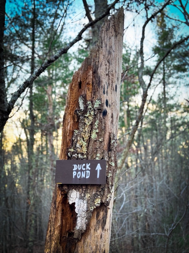
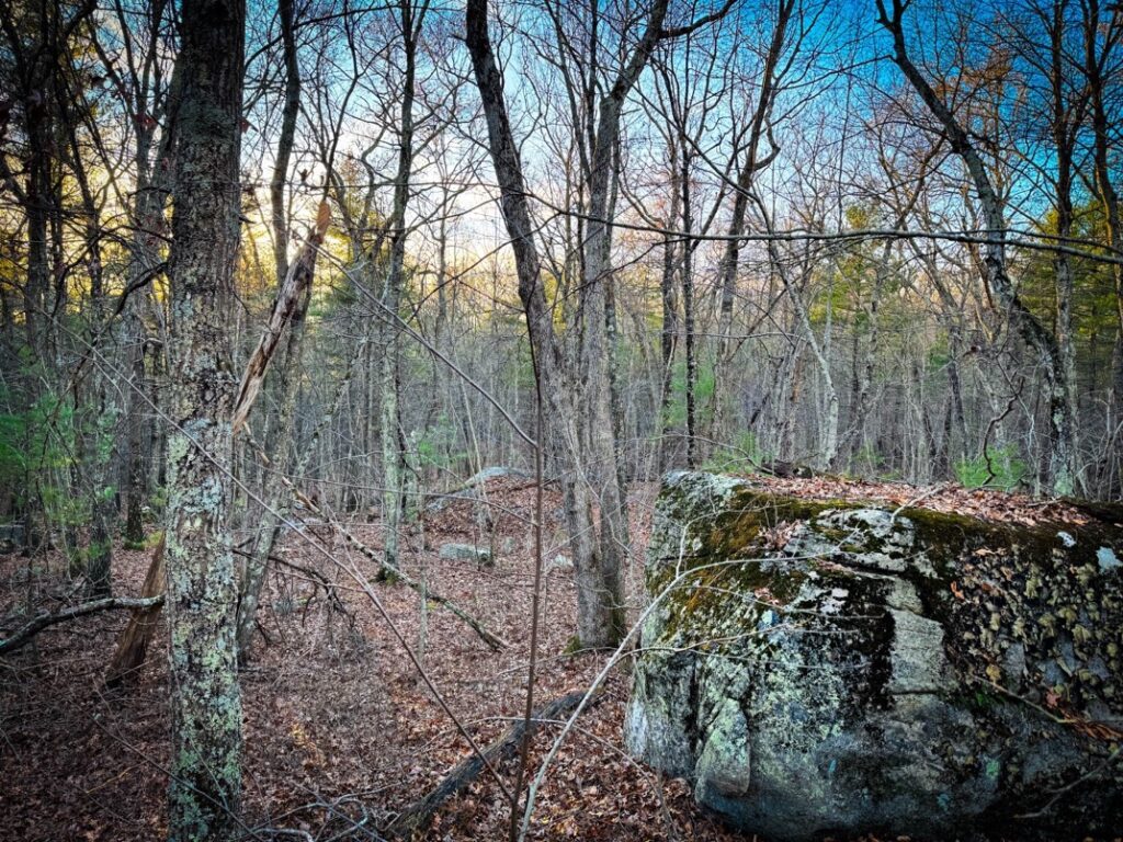
Access to the Jenner property is achieved via the Duck Pond trailhead, which is located directly behind the ranger station. The trail is wide, and outcroppings of ledge dot the landscape. It is an enjoyable walk and it’s easy to get lost in these woods if you venture too far off the trail. With the exception of the hum from I-495, the forest is silent and still.

We are left with many unanswered questions. Did the state simply decide to take Claflin’s land as their own at some point? Why did the cartographer in the 1980’s ignore the 1925 parcel map and present the Jenner property as a single parcel rather than including the 7 acre Claflin divider? And has the Jenner family been paying taxes on a larger section of land than they actually own?
From a legal standpoint the Hopkinton parcel map is superseded by the State’s, which clearly shows the unlabeled bisection. Like residential real estate transactions, towns are also required to secure title insurance. Without a clean title, it’s possible that the town may not be able to get the insurance needed to convey the property.
Most importantly, this will in all likelihood come back to voters. In the 2023 Town Meeting, Article 24 (B) was explicit in that it authorized “A sum or sums of money from funds reserved for Open Space/Undesignated Reserve for the land purchase of the Jenner Property, parcel R12 9 0. Located between Saddle Hill and Cedar Street.” It reads “parcel” not “parcels“, so in the event that the state’s map prevails, the town will not be able to purchase the land without a new vote.
Author’s note: Not a soul was in sight as I walked the trail toward the Jenner property, but as I was making my return, I saw two men in blaze orange approaching. By pure coincidence it was none other than Chuck Joseph and his son, DJ, who just happened to be out for a walk that afternoon. Joseph, as many readers know, is one of Hopkinton’s unofficial historians, and he provided several insights and anecdotes that informed my research. Mr. Joseph is giving a free lecture on Hopkinton’s history on December 13, and I encourage readers to attend.
The great Anne Mattina at the Hopkinton Historical Society provided the missing pieces of the puzzle on Dr. Briggs, who having no children, was extremely difficult to track down.
I am also grateful to Ed Harrow for his dogged research on this topic and his dedication to preserving Hopkinton’s natural beauty for generations to come.
This was a team effort!


It might be worth decoding the dimensions of the two parcels in the 1902 deed to see if the dimensions or acreage match any of the parcels in the 1925 map. The Briggs #1 parcel matches but the larger one is way bigger than the Briggs #2 parcel. However it comes closer to the right number if you include Claflin Parcel #1 into it. Might be coincidence or not, and my calculations are approximate, but something is clearly amiss. Whatever, the two Briggs parcels conveyed in 1902 are obviously not abutting.
Such inaccuracies are not uncommon. We had a survey done as part of an addition, and the surveyors noted that: “The “metes and bounds” found in the historical information suggests that more land area is available for parcel configurations than actually exists in this area.” In other words, in our section of Hayden Rowe, there’s more frontage listed in deeds, than actually exists.
Seems like the town should work with the state to resolve the issue; the end result is state-owned or town-owned public land, which is a benefit. As the end result is essentially the same, it hopefully won’t take too much effort to resolve.
The area as described has an open canal running thru it that provides water to the Hopkinton Reservoir.
There is an underground aqueduct that runs from Whitehall Reservoir, thru the Larter property, under rt 495, and fills Duck Pond on Saddle Hill Road. The open canal runs from Duck Pond to the Reservoir. This was all done during the 1890’s when the reservoir was constructed.